
Large parts of southeast Queensland and northern New South Wales remain under threat from flash flooding and damaging winds, with nearly 290,000 properties still without power on Sunday due to the aftermath of ex-Tropical Cyclone Alfred.
The downgraded cyclone made landfall just north of Brisbane overnight as a tropical low, but the Bureau of Meteorology has warned of ongoing severe weather, forecasting up to 700mm of rainfall and destructive winds through to Monday.
Emergency Evacuations and Rescues
Authorities ordered evacuations in Hervey Bay on Sunday, where a public safety declaration granted police special powers for emergency operations. Officers rescued nine people from homes and seven from stranded vehicles. The Fraser Coast also remained under an emergency alert.
Tragedy struck near the NSW town of Dorrigo, where the body of a 61-year-old man was recovered late Saturday. He had been swept off a bridge by fast-moving floodwaters on Friday, with his ute carried away at Megan, 25km north of Dorrigo.
Meanwhile, two military trucks carrying Australian Defence Force (ADF) personnel assisting in road-clearing efforts crashed near Lismore on Saturday evening. The first truck rolled over, and the second lost control while trying to avoid it. Of the 32 Brisbane-based soldiers involved, 13 were injured, with six suffering serious injuries.
Prime Minister Anthony Albanese praised the ADF personnel, calling them “heroes who were on their way to help people in need” and expressing gratitude to emergency responders for their swift assistance.
Widespread Power Outages and Flight Disruptions
By Sunday afternoon, 272,000 properties in southeast Queensland and 16,000 in NSW were still without electricity. However, power company Energex reported restoring service to 40,000 Queensland properties throughout the day.
Air travel in the region began resuming gradually, with limited passenger flights departing from Brisbane and Gold Coast airports.
Heavy Rainfall and Flood Risks Continue
The Bureau of Meteorology warned that swollen rivers and flash flooding remain a major threat. Meteorologist Sue Oates said the system’s primary hazard is now heavy rainfall, with isolated areas expected to receive up to 400mm. Another weather trough from central Australia is dragging the low-pressure system inland, increasing the risk of flooding in northern NSW.
Dean Narramore, another bureau meteorologist, said conditions in southeast Queensland should ease starting Monday, with coastal NSW seeing improvements by mid-to-late week.
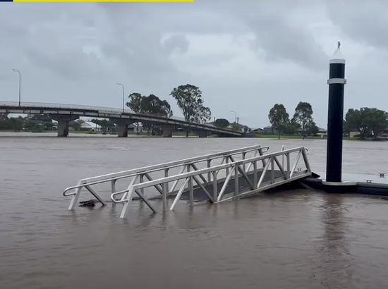
On Sunday, flash flooding was reported across Brisbane, with suburban creeks spilling over. Enoggera Creek overflowed, submerging bridges and walkways. Toowoomba recorded wind gusts nearing 100km/h on Saturday night.
Major Flood Warnings in Place
As of Sunday afternoon, major flood warnings remained for the Bremer and Logan rivers, as well as Warrill Creek. In northern NSW, river levels in Lismore’s CBD peaked at 9.31m on Saturday, just below the levee height, and were slowly receding. Emergency alerts in Lismore were downgraded from “evacuate” to “return with caution.”
Flood warnings were still active for the Richmond, Clarence, and Orara rivers, while other rivers had been downgraded to moderate or minor warnings.
Lismore’s deputy mayor, Jeri Hall, reported that around 600 people had sought shelter in evacuation centers, with some residents enduring power and water outages for more than 72 hours.
Authorities continue to monitor conditions closely as recovery efforts intensify.